


7.5
km
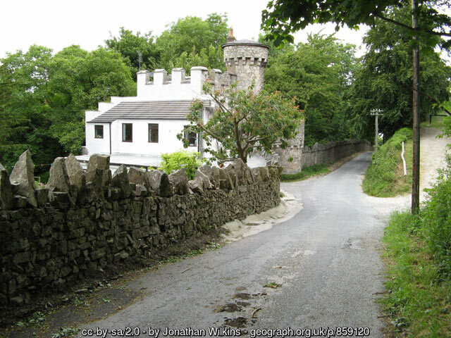
8k Run Abergele: Scenic Trail Through Woodland and Historic Castell Cawr
1:01:13
Estimate
194.6 m
Ascent
65%
Paved
4/5
Hilly
CPs
Elevation
0.0 km
2.0 km
3.9 km
5.9 km
7.8 km
101 m
1 m
Route Overview & Local Insights
This 7.8km loop offers a refreshing blend of terrains for runners seeking a mix of road and woodland trail in the heart of Conwy. Starting from Llanfair Road, you’ll tackle a moderately hilly course with 195m of ascent, most notably as you circle the base of Castell Cawr. The route is approximately 65% paved, making it a great hybrid run where you can maintain a steady rhythm on the tarmac before navigating the softer, more technical paths near Bryn Gwenallt and the riverside. Expect sweeping views of the North Wales coastline and a peaceful final stretch following the river back into the center of Abergele.
Steeped in Iron Age history, the area around Castell Cawr (Giant’s Castle) is famously topped by an ancient hillfort, providing a dramatic backdrop to your workout. As you pass the grounds of the local hospital and wind through the dense woodland, you are running through a landscape that has long served as a gateway between the sea and the rugged hills of the Gele valley. Local runners often favor this route for its sheltered forest sections which provide cover during windy Welsh days, and the proximity to the town’s cafes makes it a perfect choice for a post-run recovery coffee.
Plan Your Run
Pace Calculator
Calculate your splits for this 7.8km hilly woodland circuit.
5k Training Plan
Building up from 5k? This route is a perfect next step for endurance.
Injury Prevention
Stay safe on uneven woodland trails and hilly descents.
Nutrition Tools
Fuel properly for nearly 200m of elevation gain in Abergele.
This course includes one or more areas where higher levels of caution are recommended and your time is temporarily paused. We suggest reviewing the map in close up, where these sections are shown with dashed lines.
This course includes 0.3 km sections of dashed lines. The total distance for the course including these sections is 7.8 km
We use Cookies
This website uses cookies to ensure you get the best experience on our website.